Sunday 27 June 2010

Beinn Odhar June 2010


I suppose you could call Beinn Odhar the little brother of Ben Dorain as there isnt a drastic height difference beteween them. This is another mountain (A Corbett by just 13 metres), that we all bomb past on the A82 on the way to the giants in Glen Coe. Now that i've climbed this one, I think we should all show it a bit more respect. You start at the Tourist information Car Park in Tyndrum. Best not to Park in the Green Welly Car park as you might get told off. We met up at the Welly for breakfast (Me, Jim and John). I had the full Scottish but my collegues are lightweights and opted for a cup of Tea and a bun!!


Its a nice walk intowards Odhar, along the West Highland way route for around 2km. You reach a Fence and gate and from here you leave the WHW and go up. You reach a simple memorial stone a few hundred metres from the gate. It's a memoral to a 19 year old who 'loved the highlands'. It was here that John decided to let us carry on up and he would walk along the WHW to Bridge of Orchy and back. It quickly becomes very steep and rocky, with no paths to follow.


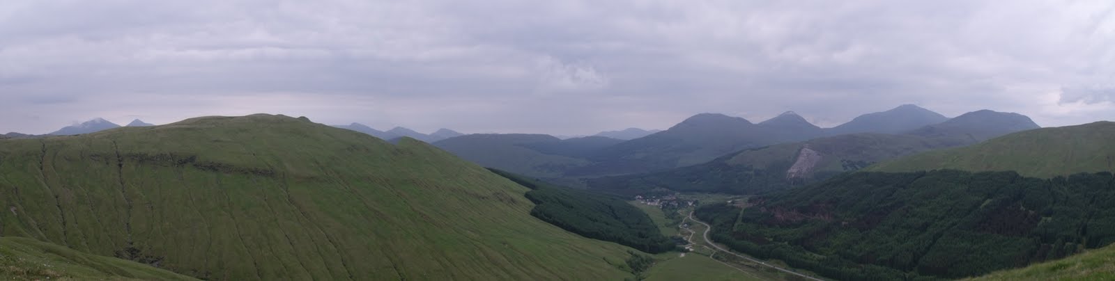
The views are amazing though. We could identify mountains across to Ben Oss and Lui, over to the Crainlarich hills including Ben More and Stob binnein. Ben Starav and Loch Etive could be seen, as could the mountains of Glen Coe. It was very hot and for most of the accent there was no breeze. Quite by accident we came across a huge gash in the mountain side, which led us down into a cave. Unfortunately we hadn't brought torches so couldnt explore. We then reached a small plateau on which was a lovely shallow lochan, a perfect wild camping site. The final haul up to the summit is tough going, through boulder fields on very steep terrain. But finally as you near the summit you see the tip of Ben Dorain sticking up, letting you know you dont have far to go. Theres a hugh cairn on the summit of Odhar and the most spectacular views all around you.

We had planned to decend via Meall Buidhe but the midges were out in force and opted to decent to Lochan Choire Dhuidh and then down through the rock river bed of Choire Dhuidh. With us being in the middle of a long dry spell it was safe to navigate this.

 It turned out to be the best part of the day (as you will seee from the photos). It was a very steep decent, first through grassy meadows then razor edged banks and then onto the rocky floor of the now dry river  bed.

We passed a few small pools and a couple of trickling waterfalls until we rejoined the WHW at the railway bridge where we started out climb 4 hours earlier.

Saturday 19 June 2010

Schiehallion June 2010

Schiehallion has been one of those mountains on my 'to do' list for years now and finally i can tick it off as done!!


It's not a spectacularly pretty mountain to look at and its not one that has your hair standing on end as you climb it. Its a 'whale back' mountain, which in other words is just a slow slog uphill!! Getting there is a task in itsself. The car park at foss braes is tucked away in a beautiful glen on the road towards rannoch moor and is an empty land!!!
I had camped the night before at a farm that allows a small number of caravans and tents to pitch on its grounds for a very small fee (i'm not going to tell you where as i dont want its peace and quiet ruined by you all stampeding to stay there!!).

 Left the car park at the mountains foot just before 8am. I started early so to enjoy the cooler morning temperatures as the day before had been very very hot and wouldnt have made comfortable climbing. I was taken aback when i saw that the car park had a pay and display meter, its in the middle of nowhere and i wondered who and hopw often a traffic warden did his rounds out here. But i duly paid my £2 fee for the right to park and started my walk. Its an easy path for the first couple of miles, following a well laid and maintained path (courtesy of the John Muir Trust). It zig zags its way through some trees and then makes its way, quite steeply onto the back of the mountain. It was already begining to heat up, but was still a bit hazy, the sun only just begining to melt the clouds. Its a tough old slog up this monutain until you get to a huge cairn on a small flat clearing. This is where the path ends and the 'scramble' begins. The remaining mountain is strewn with boulder fields and carins to guide you on your way.UP!!

There are numerous false summits on this mountain, but if you are a geologist there is plenty to keep your attention. The wind picked up and i had to don my fleece as I approached the top. And what a view. Its a very narrow summit with near sheer drops all around, which adds to the dramatic views over to rannoch moor and the black mount. I never saw another soul until i turned to start my return to the car and on my decent passed around a dozen people, including a couple of fell runners. It was a good day and i'm glad i finally took the time to tackle this one. The guide books say it takes a round trip time of 4.5 hours. I was back at the car for 11am, so just over 3 hours for me which was fairly quick, considering i spent around 15 minutes at the top taking photos and having something to eat. However, i do think i should have set off a bit later as by the time i reached halfway on my decent the clouds had all cleared and the views would have been even better from the summit, but i wasnt going to turn round and climb throughy the scree again!!Maybe next time.